CBSE
Class 10 Class 12
Download this Geography Pre Board Paper 1 for taking the test offline or sharing with your friends. Once you are done with all the answers to the questions, Go ahead with answer key to check your answers.

| 1. |
Which continent has the highest growth rate of population? | [1] |
| 2. |
Define the term 'quaternary activities.’ | [1] |
| 3. |
Why is West Asia the least developed in rail facilities ? Explain one reason. | [1] |
| 4. |
Which form of rural settlement pattern develops along roads, railway-lines, rivers and canals in the world ? | [1] |
| 5. |
Mention any two sources of water pollutants created by humans. | [1] |
| 6. |
Which major sea port on the eastern coast of India has a land-locked harbour ? | [1] |
| 7. |
Name the two metropolitan cities which are the main polluters of river Ganga before it reaches Varanasi. | [1] |
| 8. |
Explain the concept of ‘Determinism’ with suitable examples. | [3] |
| 9. |
Explain any three characteristics of 'Foot Loose Industries'. | [3] |
| 10. |
Explain any three characteristics of clustered rural settlements of India. | [3] |
| 11. |
Why ports are called ‘gateways of international trade’? Explain any three reasons. | [3] |
| 12. |
What is the main cause of formation of ‘urban smog’? | [3] |
| 13. |
Mention the famous oil pipeline of the U.S.A. How are pipeline one of the most convenient mode of transport? Explain any four points. | [3] |
| 14. |
What is sex ratio ? Explain the world pattern of sex ratio with suitable examples. | [5] |
| 15. |
Describe any five characteristics of ‘Commercial Livestock Rearing’, practised in the World.
| [5] |
| 16. |
Distinguish between ports and harbours. Why are sea ports known as gateways of international trade? Explain. | [5] |
| 17. |
What is human development ? Analyse the four pillars of human development. | [5] |
| 18. |
Review any five measures adopted to solve the problems of Indian agriculture. | [5] |
| 19. |
Define the term ‘Road Density’. Explain with examples the two main determinants of road density in India. | [5] |
| 20. |
How does access to source of energy and labour supply influence industrial location in the world? Explain with three examples. | [5] |
| 21. |
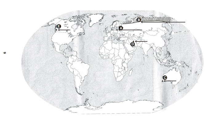
In the given political outline map of the world, five features A, B, C, D and E are marked. Identify these features with the help of the following information and write their correct names on its lines drawn near them : (A) The country having the lowest population growth rate. (B) The area of nomadic herding. (C) The terminal station of trans-continental railway (D) Mega City (E) Sea Port | [5] |
| 22. |
On the given political outline map of India, locate and label the following with appropriate symbols: (i)The state having the highest percentage of population below the poverty line. (ii) The software technology park in Uttarakhand. (iii) The State leading in coffee production. (iv) An oil refinery in Bihar. (v) The largest metropolitan city of India (2001) | [5] |