 Long Answer Type
Explain the three components of population change in the world. Analyse the impacts of population change.
Describe any five characteristics of ‘Commercial Livestock Rearing’, practised in the World.
Differentiate between bilateral trade and multilateral trade. Explain how ports are helpful in trade.
Describe any five patterns of rural settlements in the world on the basis of forms or shapes.
Patterns of rural settlements in the world on the basis of forms or shapes:
(i) Linear pattern- In such settlements houses are located along a road, railway line, river, canal edge of a valley or along a levee.
(ii) Rectangular pattern- Such patterns of rural settlements are found in plain areas or wide inter montane valleys. The roads are rectangular and cut each other at right angles.
(iii) Circular pattern- Circular villages develop around lakes, tanks and sometimes the village is planned in such a way that the central part remains open and is used for keeping the animals to protect them from wild animals.
(iv) Star like pattern- Where several roads converge, star shaped settlements develop by the houses built along the roads.
(v) T-shaped, Y-shaped, Cross-shaped or cruciform settlements- T-shaped settlements develop at tri-junctions of the roads (T) while (Y) shaped settlements emerge as the places where two roads converge on the third one and houses are built along these roads.
The decades 1921-51 are referred to as the period of steady growth of population whereas the decades 1951-1981 are referred to as the period of population explosion in India. Explain giving reasons.
(26.1) In the given political outline Map of the World, four features A, B, C and D have been shown. Identify these features with the help of information given below and write their correct names on the lines drawn near them.
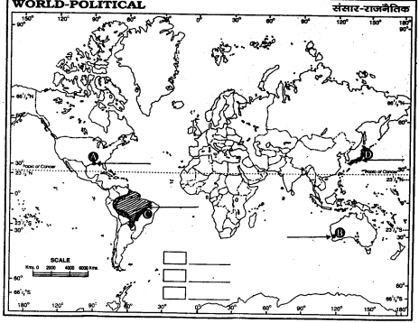
A: An important sea port
B: A terminal station of Australian Trans-Continental Railway
C: An area of subsistence gathering
D: The country with lowest growth rate of population (1995-2000) in Asia.
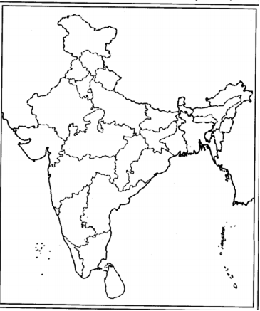
(26.2) On the given political outline Map of India, locate and label the following with appropriate symbols:
A. The state having highest literacy rate.
B. The leading state in the production of Jute.
C. The northern most international airport.


 Switch


