Subject

Geography

Class

CBSE Class 12

Pre Boards

Practice to excel and get familiar with the paper pattern and the type of questions. Check you answers with answer keys provided.

Sample Papers

Download the PDF Sample Papers Free for off line practice and view the Solutions online.
Advertisement

 Multiple Choice QuestionsShort Answer Type

11.

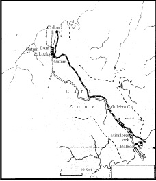
Study the map given below carefully and answer the questions that follow :

10.1. Identify and name the canal shown in the map.

10.2. State any four features of this canal.

867 Views

12.

Distinguish between clustered and semiclustered rural settlements of India, stating three points of distinction.

402 Views

13.

Describe any three features of Konkan Railway.

532 Views

14.

“Air pollution is very harmful to flora, fauna and property.” Explain any three values which can help in maintaining pollution free air to some extent.

356 Views

Advertisement
15.

Locate and label the following features with appropriate symbols on the given political outline map of India:

(i) The most urbanized state (2011).
(ii) The leading cotton producing state.
(iii) The Software Technology park located in Punjab.
(iv) The major coal field located in Chhattisgarh.
(v) The international airport located in Karnataka.
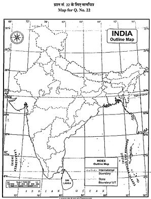
346 Views

 Multiple Choice QuestionsLong Answer Type

16.

What are the two types of subsistence agriculture practised in different countries of the
world ? Describe the main features of these types.

464 Views

Advertisement

17.

What is the meaning of density of population ? Examine the four geographical factors that influence the distribution of population in the world with suitable examples.


Population Density refers to the ratio between the number of people to the size of the land or the number of people inhabiting per unit of land.

Geographical factors influencing the distribution of population are:

  1. Availability of water: It is the most important factor for life. So, people prefer to live in areas where fresh water is easily available. Water is used for drinking, bathing and cooking – and also for cattle, crops, industries and navigation. It is because of this that river valleys are among the most densely populated areas of the world for eg: The Ganga plains are densely populated.
  2. Landforms: People prefer living on flat plains and gentle slopes because such areas are favourable for the production of crops and to build roads and industries. The mountainous and hilly areas hinder the development of transport network and hence initially do not favour agricultural and industrial development. So, these areas tend to be less populated. For eg: The Ganga plains are among the most densely populated areas of the world while the mountains zones in the Himalayas are scarcely populated.
  3. Climate: An extreme climate such as very hot or cold deserts are uncomfortable for human habitation. Areas with a comfortable climate, where there is not much seasonal variation attract more people. Areas with very heavy rainfall or extreme and harsh climates have low population. For eg: All mediterranean regions are inhabited from early periods due to their pleasant climate.
  4.  Soils: Fertile soils are important for agricultural and allied activities. Therefore, areas which have fertile loamy soils have more people living on them as these can support intensive agriculture. For eg: Indo-gangetic plain in India are the most fertile lands for agruculture.
283 Views

Advertisement
18.

Why do large scale industries choose different locations ? Explain any four factors which influence the industrial location.

682 Views

Advertisement
19.

“Scarcity of water on account of its increased demand, possess possibility the greatest demand in India.” Analyse the statement.

275 Views

20.

Explain any five factors responsible for the development of ‘Hugli Industrial Region’.

568 Views

Advertisement